Saturday 30 January 2010

Day 8 Cradle Mountain NP - Rosebery

Date: 13/JAN/2010
Route:Cradle Mountain National Park - Tullah - Rosebery
Distance: 93km
Accident: 0
Puncture: 0
Weather: Cloudy, drizzle, fine, drizzle again then cloudy and finally sunny
Accommodation: Rosebery Caravan & Tourist Park ($10 / Unpowered)

This morning was freezing! I was waring extra clothes but still very cold. That's the mountain weather. What's more this place's weather is so unstable (see the weather above) . One moment sunny but the next moment is rainy. I couldn't believe it was in the middle of summer there.

I went to the national park area of Cradle Mountain before heading to the west. I did the famous 6km Dove Lake Circuit Walk. This lake walk took me to some of the best spots view the cradle mountain. The weather was initially raining but as went on it got better and I could partly see the mountain under the blue sky. The walk was about 1.5h and it was very easy walk with one moderate hill.


World Heritage Listed Cradle Mountain and Dove Lake - Cradle Mountain


An alpine plant - Cradle Mountain

After the walk, I packed up all my stuff and headed the west. I got the highest development road of cradle mountain (930m).


I am on the top! - Cradle Mountain


When I was resting the point I came across other cycle tourists. They were German couple and French man. I was surprised by their bikes their bikes were massive, they were probably mountain bikes based touring bike and all the touring equipments were loaded and there luggage was also massive. The couple had been travelling in Australia for 2 years and the man was 5 years! I see that's why. I want to ride like that one day with no time restriction how fun it would be.


The German and French Cycle Tourists - Cradle Mountain


After the highest point, I was going down, down, down, down, down, down, down , and up!!! Then today's bed, Rosebery.


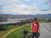
Down, Down, Down! - Road C132

This town is a small mining town so this town is not touristy at all. However, I liked this town, because of its surroundings. (Remark* I tend to like places which is not too touristy.) Although this small town don't have much to offer to tourists it is completely surrounded by mountains so the view from was great and air is fresh and clear.

Well tomorrow I am heading to Queenstown via Zeehan. I assume it will be a great history learning day ride.

It is getting dark. Have a good night.

Today's route

View Larger Map

Friday 29 January 2010

Day 7 Deloraine to Cradle Mountain NP

Date: 12/JAN/2010
Route:Deloraine - Sheffield - Cradle Mountain National Park
Distance: 96km
Accident: 0
Puncture: 0
Weather: Cloudy then rainy and windy
Accommodation: Cradle Mountain Tourist Park ($32 / Unpowered)

Today was the day of climbing.

I woke up at 5.15am and so Mikko did as I suggested him to wake up to early so that he could ride longer. We had long breakfast till around 6.00am because I ate a lot and we talked as well. I packed up all my stuff at 7.00am and so he did. Today, I was heading west and he was heading east. That was time for farewell. I wished him luck and started today's ride.

The first part of today's ride was between Derolaine to Sheffield. It started with flat, relatively down hill ish road. So I was feeling great. And as far as I saw on the map there was no major hill till Sheffield. However, just before 7 or 8 km Sheffield the situation changed dramatically. (Between two towns are about 30km) It suddenly became continuous and very steep uphills. As I didn't expect the hills, I felt like I am fish caught by a fisherman while I am swimming nicely. It was totally unexpected when this happen my body can't react to the fact because my body was not ready as well. Normally this things doesn't happen often but.... Tasmania, what a sharp state you are.

Anyway, I finally, managed the row of the hills and got to a flat area, it was definitely the top as I couldn't find any higher area from there. It was very beautiful road. It was narrow and probably road for farmers vehicles or something but, I could feel it was like riding in the French Alps (although I've never been there). On the right hand side was like a cliff and on the left hand side was farm filled with full of golden pampas grasses (or some sort).


It was like that - a few km before Sheffield

I got to Sheffield at about 9.30am. I had second breakfast and got into the visitor centre. I bought the 8 weeks National Park Entry Pass ($30). I was entering the national park area today and if you got to more than 2 national parks its cheaper to get this pass. I was planning to go to several parks in this trip so I bought this pass.

Sheffield was a very unique town to me. As the town itself was an art gallery. Actually the town called itself as "outdoor art galley" There were few good looking cafes as well.


Outdoor Art Gallery - Sheffield Town Centre

As I was expecting a big and long climbing I did not have much time to waste in Sheffield. After leaving Sheffield, massive and ragged rocky Mt. Rowland was standing in front of me for a while while I was riding the base of the Mountain. Once I was over the Mt Rowland there was a huge decent waiting for me. Normally I get excited with decent but as this decent seemed to go forever, and I was supposed to climbing a mountain. Consequently, I realised that that decent was the last treat of today.


Ragged Mt Rowland with a horse - Mt Rowland

Immediately after this long down hills, there was a long and crazily hilly road was there, and that was i would say the starting point of today's ride.


Steep hills - Between Sheffield and Cradle Mountain

As it was so hilly I had to shift the gear to low and of course had to keep pedaling. When it was hilly I was just going 6km/h. and I was sweating a lot. On the top of the hill, there was a cafe. (Nice!) I had a can of Solo and Toasted Sandwich for $13 all together. It was expensive but was bloody good!

There was about 25-30km left to today's goal point. I though it would be easy as I had done the hardest parts already. Not at all. I think today was the day of hard riding. It started raining and strong wind was blowing against me. So I was wet and very slow for the rest of the ride.


Cold and wet - Near Cradle Mountain NP

I got to today's goal, Cradle Mountain National Park at around 4.00pm. The weather is still not very nice so I will do the walk in the National Park tomorrow morning before I head to Rosebery.

It is fun to see people's reaction here about me, a man riding in the middle of nowhere like here. They look at me as either a crazy person or well done! Maybe 70% react like the first one and rest of 30% react like the second one.

That's it. It was a long day for me today. Good night.

Today's Route

View Larger Map

Thursday 28 January 2010

Day 6 Lilydale to Deloraine

Date: 11/JAN/2010
Route:Lilydale - Launceston - Perth - Westbury - Deloraine
Distance: 106km
Accident: 0
Puncture: 0
Weather: Fine
Accommodation: Deloraine Caravan Park ($10 / Unpowered)

Today's ride can divided into two parts. From Lilydale to Launceston, and Launceston to Deloraine.

The first half's trend was downhill as Lilydale was on the hillside and Lanceston was almost on the sea level. Easy cruising to Launceston. Civilization! Yes, Launceston is the second largest town in Tasmania. Where civilization where good eateries are. I sat in a cafe in a strip in the town centre and ordered its big breakfast. That was spot on! It came with 2 pieces of thick toast, few slices of well cooked bacon, few pieces of sausages, a well sauteed fresh sliced thick tomato and 2 lightly poached eggs. The sauce was hollander. Just right, mate. Having had eaten only cold food for the past day, this breakfast with a cup of latte was real luxurious moment.


Princess Square - Launceston

After breakfast, I wondered around the town briefly. There were some well maintained Victorian style grass gardens with in the city like Princess Square. There was interesting botanical garden as well. I found the town was quite artistic and made it very pretty. I wanted to check out the wine in this region as well, but unfortunately, the time didn't allow me to do it. So after the brief tour of Launceston, I left this town behind. (I will come back next time!)

Well, back to ride. The second half was pretty flat ish rather boring road as I did rode on very busy and not scenic highway by accident.

On the way I did a bit of detour as I found a interesting town in the south of Launceston. The name of the town was Perth. That where I came from. It was small heritage town. I had a chance to talk to a residence of Perth to ask about the connection or relationship between Perth in WA and Perth in TAS. There was none. None at all. It is always interesting to do a detour.


Welcome back to Perth? - Perth

Anyway, from Perth, I was riding toward west. I was riding on the busy highway (HW1) not knowing there was a nice and quiet side road (B54) just next to the highway. Although there was enough space to ride on the road as there was a reasonably wide shoulder on aside, riding next to bullet-speed trucks and road trains was not very present. The terrain was fairly flat so I was just riding and thinking something else in order to make time pass.

I finally realised the existence of the side road when I got to Westbury which was 16km before today's destination.

I stopped at Westbury for the last break for the today's ride. There was a bakery called Andy's Bakery. I had a pie there. It was very good.
During the break. I had a chat with a man who was the principal of a primary school in Tassie. After telling about my trip, we had a short but good conversation about the issue of the private education in Australia. It needs to be changed, it needs a decent quality control to the education and to the system itself. That was our conclusion. (Anyway, it is a bit out of the track from the topic of this blog so I will write about this issue on my blog when I have time.)


Looks like Window's default background - Between Westbury and Deloraine

Back to the saddle, from Westbury to today's goal, Deloraine was flat short ride. I made it to Deloraine at 3.00pm.


Some sort of art? - Entrance of Deloraine

Deloraine is a pretty riverside town with the population of 5,000. Along the main strip there were quiet boutique restaurants and cafes. I really liked this town because this nice cafe feeling with beautiful river, which was swimmable, and the town had a full of bits and pieces of arts everywhere in town. The people seemed very friendly (very used to looking after tourists in a good way) as well.


Beautiful Swimmable River (view from my tent) - Deloraine

I pitched my tent in the caravan park, which was right next to the river. Of course I swam in the river as it was particularly hot day for Tasmaia (probably over 30 c). I met another cycle tourist at this camp site. His name was Mikko from Philippines. He just arrived in Tasmania from Melbourne by ship, Spirit of Tasmania and rode to Deloraine (49km). We had dinner at on the main street's snack bar, then, bought some beer (Boag's Draft, Launceston's Premium Beer) at the bottle shop, walked back to the campsite and had a small party right front of the river with many ducks.

It was a good night. Everything was just right.

Today's Route

View Larger Map

Wednesday 27 January 2010

Day 5 Port St Helens to Lilydale

Date: 10/JAN/2010
Route:St Helens - Derby - Scottsdale - Lilydale
Distance: 145km
Accident: 0
Puncture: 0
Weather: Cloudy then fine
Accommodation: Lilydale Falls Reserve (Free / Toilets and Water Falls)

This morning I was up at 5.3oish and had a slow breakfast as there was a TV in the campers' kitchen and it was showing 80's pop music.

As soon as I left St Helens many hills were waiting for me from moderate hills, normal hills, extremely steep hills, short hills to long hills. So today was the day of hills, I would say. Therefore It was a challenging terrain but the scenery was amazing as well.


Feeling like the Jurassic Period - Weldborough Pass Rainforest Walk


Like snow - Near Derby


Fish in the wood - Derby

In Derby I met a group of cycle tourists. They are from Germany, France and Australia. One of the guys were travelling with $175 bike from K-mart so the peddles and seat post was already bent with this rolling hills. That was legend, mate.

That was the major event of today. Otherwise I was riding, riding and riding for whole day from 7.00am to 5.30pm as I wanted to go as further as possible.

The campsite didn't have a shower so I took a natural shower under a fall. I felt like very wild today. Like the Man vs Wild. :)

You have to do this to survive - Lilydale Falls

All good but very tired today. My legs need good rest tonight. Good night.


Tea Time


Today's Route

View Larger Map

Tuesday 26 January 2010

Day 4 Bicheno to St Helens

Date: 09/JAN/2010
Route:Bicheno - St Helens - Binalong Bay - Bay of Fires - St Helens
Distance: 116.90km
Accident: 0
Puncture: 0
Weather: Fine then cloudy and windy
Accommodation:BIG4 St Helens Caravan Park ($33 / Unpowered Site)

Started the day with the farewell for James, today's goal was Tassie's most visited natural attraction Bay of Fires where Tasmania's best beaches are. The ride was smooth as I got a reasonable tail wind for the first 30 to 40km. Terrain was basically flat with oceanic and forestry views. There was hardly no traffic!


Ragged Mountain - A3 HWY

I arrived at today's bed, St Helens at 11.30am. This caravan park, BIG3 was extremely expensive ($33/ Camp Site). Well, its a well facilitatd caravan park with new kitchen, clean bathroom and plenty of kids playing ground but I thought they are too profit oriented. It's not my taste, I like more wild places.


St Helens

Anyway, thinking this sort of thing I piched the tent, left all the heavy stuff in the tent, I went to check out the best beaches in Tassie. Bay of Fires was about 12km north east of St Helens. The beachs were massive and beautiful, but I realised one thing. Although there are beautiful beaches and a quiet a few number of tourists here but why no one is swimming in the beach?

I was expecting to swim here so jumped in the beach. I immediately realised why people don't swim there. The water was FREEEEEEEEZING. Couldn't hardly stay in the water for few minutes.

Its a not swimming place, nice viewing beaches.


Beautiful Sandy Beach - Bay of Fires


Like some resort island - Binalong Bay
Then, I went back to St Helens, did shopping, had some snack, and now I am writing this diary.

Another day was over, it seems to be going to be a hard day tomorrow with a lot of climbing so I will do a lot of stretching tonight and go to bed early enough. Good night.

Today's Route

View Larger Map

Monday 25 January 2010

Day 3 Triabunna to Bicheno

Date: 08/JAN/2010
Route:Triabunna - Swansea - Bicheno
Distance: 99km
Accident: 0
Puncture: 0
Weather: Cloudy
Accommodation: Bicheno East Coast Holiday Park ($10 / Unpowered Site)

I woke up with feeling a need to urinate at 5.30am. Thanks to the feeling, I could have a head start this morning. I left the caravan park at just after 6.00am.

The first half ride for today was supposed to be easy as as there was no hills and very few traffic. But it was not that easy as I got a strong head wind constantly for the first 30km. It was actually pretty hard.

On the way I stopped by a beachfront free campsite, Mayfield Camp Site between Swansea and Triabunna. Although there was no shower facility, it looked like a really nice spot to stay couple of days. (and it's free!)

Apparently, there are a number of free (or very cheap) campsites around Tasmania and they are managed by the state and normally located in a remote area. As cycle tourist its best to have shops near by but these campsites have perfect location to enjoy the nature, so I want to try some during this trip.

After arriving in Swansea, I saw a guy with a bike. It must be a cycle tourist! Yes he was. I was a bit excited as it was my first time to talk other cycle tourist.

We had coffee and had a chat. His name was James from Canada. He was riding from Hobart as he got some time to spare in Australia. What's a nice idea. He was also heading to the north to Bicheno.

As I was heading north but different way, I suggested him a my plan for today, to take a private boat service from the end of Nine Mile Beach to near Coles Bay, which is the closest town to Freycinet National Park, one of Tasmania's most famous National Park with its pristine coastline and walking tracks. In this way, we could save 50km easily and able to see and walk the National Park in the same day. He liked the idea and we decided to take a ferry.

But, that day the ferry was not operating due to the wind. (or due to trublesomeness.. who knows) So the plan wouldn't work as bikes cant cross the sea.

oops, travelling is a full of uncertintity.

So we gave up the National Park and headed Bicheno, another sleepy coastal side holiday town.
The first 25km was flat kind of boring road with few traffic with tail winds. After 25km all the suddent the scenery got into beauftiful forest.


Forrest Opens - A3 HWY

Just before Bicheno I stpped at strawberry farm to have its strawberrry sorbet. It was a great treat.


Strawberry Treat - Strawberry Farm Near Bicheno

Finally I got to Bicheno at 1.15pm. It is always best to get to a day's destiation earlier, because I can look around the area. I went to see the town's attractions such as ragged beaches, blow holes, and a swimming beach. Unfortunately, the weather of the day wasn't perfect to enjoy all these places so it was all right for me. But its always fun to explore new places.

Blow Hole - Bicheno

This night, James and I went to a local restaurant for dinner. Great to have a company for dinner and decent dinner. Had a good night and went to bed fairly late 8.30pm.

Today's Route

View Larger Map

Sunday 24 January 2010

Day 2 Port Arthur to Triabunna

Date: 07/JAN/2010
Route: Port Arthur - Copping - Wielangta Forest Drive - Orford - Triabunna
Distance: 96km
Accident: 0
Puncture: 0
Weather: Fine (Beautiful!)
Accommodation: Tribunna Cabin & Caravan Park ($15 / Unpowered Site)
Good timing - Near Eaglehawk Neck

Another long day ride! I left Port Auther at late time of 7.30am. My alarm clock didn't work this morning plus the wine from the last night made me overslept for an hour.

The first 30 - 40 km to Copping was very smooth not as hard as yesterday even I was going back the same way.


The first stop for today was Copping, a small town end of two peninsulas. I had a extra large chicken burger for breakfast (yum!). When I was eating it, one friendly local cobber* talked to me as he saw my bike in front of the milk bar**.

*a cobber: a man
**a milk bar:a small shop selling milk and other basic provisions

He told me that the road which I was approaching was partly closed as the bridge was down. Down? sounds pretty wild. but he said with grin "you'll be fine, you can carry your bike and cross the river'. and he actually recommended to go ahead on that road as the road was really scenic way and nicely compressed dirt road. So I felt a bit relieved.

If I conclude what happened next, the next 35km was hell hard. As it mentioned on the map it was gravel. It was good at the beginning as the road was nicely compressed but as I get into the forest deeper and deeper the road become more and more bumpy and hilly. It wasn't gravel in the end I guess IT WAS ROCKY. But as the road was partly closed, there were hardly any cars on the way for this 35km and it was really scenic road as well with forest ocean views.


Scenic but Hard - Wielangta Forest Drive

Having ridden the long gravel (rocky) road, the front carrier has got damaged a bit (but easily fixable) but nothing went wrong with the bike because it was a bit of challenge as I didn't set up my bike for gravel roads. Good.


Beautiful Coastlines - Near Orford

From the end of the gravel road there was a small sleepy seaside town of Orford. Form there to today's destination, Tribabunna was easy flat ride of 7km.

Got to a caravan park here and writing this blog. Oh, its 7.30 I have to go to bed soon!

Today's Route

View Larger Map


Saturday 9 January 2010

Day 1 Hobart to Port Arthur

Date: 06/JAN/2010
Route: Hobart - Richmond - Port Arthur
Distance: 135km
Accident: 0
Puncture: 0
Weather: Cloudy + Drizzle then fine
Accommodation: Port Arthur Caravan Park ($17 / Unpowered Site)

The first ride in Tassie. To avoid the surprisingly busy traffic due to the busiest season, I left Hobart fairly early about 6.30am. It seemed didn't work, there ware already a lot of traffic on the road of Hobart and they are not much in number but really fast. So it eventually took me 1 hour to get out of Hobart.

After the busy Hobart and got into a country road near Richmond, there was hardly any cars. That's was what I was after. That was the time when I felt Tasmania for the first time in terms of cycling.

Historic Bridge - Richmond

Got to a historic town of Richmond and checked out its historic bridge, I headed down to Port Arthur via the main road. As Port Arther is located in a peninsula in a peninsula, there were a lot of hills and good distance as well. I made it to Port Arther about 3 PM.

Pushing my heavy body I went to today's main attraction, Port Arthur. Port Arthur was used to be a massive prison for convicts. Because of its unique location (in a peninsula in a peninsula) which was perfect for building a prison, there was no walls around it at all so it didn't looked like a prison for about 50 years without hearing the history by the guide. Very interesting site.


Massive - Port Artur

After Port Arther, back to the camp site, I met two guys in the same camp area. They were travelling on motorbikes and surprisingly they were from Perth! So we talked a bit over a red wine and hit a hay around 9.00pm.

It was a hard day from the first day, but all good!!

Today's Route

View Larger Map

Monday 4 January 2010

Ride Down Under 2 - Greeting

Dear readers

Happy new year and welcome back to the blog. This bolg has been in a long sleep for a year and it's the time to wake up!

This time I am flying to Tasmania to discover the Tasmanian Wilderness of course on the bike. I hope I can spot some Tasmanian Devils alive during the trip.

I am riding form 6th of Jan and I am flying to Hobart tonight. Exciting. Hope the Y2.1K won't hit my flight.

Regards

Yohei


Happy New Year!

Sunday 3 January 2010

The Bike 2010

The Bike

Bianchi Lupo

The bike is same as the last time. I replaced some parts which were worn to new ones and also added some of the touring items. Followings are the major changes:

1. Front Panias

It is important to balance the bike weight even to make a stable ride. I haven't used the front ones before so It's a bit of excitement how the ride will differ from only back panias. Thanks to Darren and Brad for suggestion and the pania supply.

2. Special thorn resistant inner tube

Inner tubes are tend to be afterthoughts for cyclists but I don't want to get pains in a neck with flat tyre and this time I might go on the gravel roads. Found this creazy thick tube at the Ideal Cycle in Fremantle. This tube's is 3 times as thick as ordinal tubes. That's massive man. See the photo below, that the box of the tube comparason with an ordinal tube box.

So she is ready to go. Upgrading is great thing!


A bit more about the bike. The bike, Lupo, is a cycle-cross bike, which is basically a road bike with more clearance for tyres and the wider geometry of the frame. The bike is not specifically designed for cycle touring but it is a bike which enables me to ride long distance without having a pain in my ass. So that’s all I need for the touring.

Here are the specifications of my bike as follows:

Frame Cr-Mo Steel 700C Cross

Fork Cr-Mo

HandleBar : Alloy

Stem: Alloy

F.Derailleur Shimano: TIAGRA

R.Derailluer Shimano: TIAGRA

Shifter Shimano: TIAGRA STI

Brake: Tektro 992AG

Crank: Shimano TIAGRA 52/42/30

BottomBracket: Shimano BB-UN53 113/68

Saddle: Velo VL-1101

SeatPost: Alloy 26.4

Hub : Shimano TIAGRA

Casette: Shimano 13/25 9s

Rims: DA-16

Tires: DURO THE HYPERSONIC 700x23C

Inner Tube:XLC THORN RESISTANT TUBE

Pedal VP-519A

Color : Navy

Size: 55


Friday 1 January 2010

About the Ride Down Under 2

About the Ride Down Under 2


Introduction


Well, it’s been a year since I completed my first bike touring in Australia. Now, it’s time to come back. This time I am heading to overseas. Passport is needed. Yes, the second destination for the RDU is TASMANIA!

Tasmania has been attracting destination for me since I discovered about the fact that Tasmania is one of the most well known destinations to tour by bike in the world with its mountainous country and world heritage listed wilderness.

I hope to successfully and safely complete my ride and enjoy the Tour as I did last year. I hope this blog will be enjoyable one for you to read.


The Objectives


It is essential to have goals to do anything, even for a tiny thing like riding from work to home. So here are the objectives for this time. I will make them all!!


1.To beat the hills of the Tasmania

2.To visit the major tourism attraction which Tasmania offers

3.To discover and enjoy Tessie wines, daily products and natural gourmet.

4.To make the world a bit more bike friendly

And most importantly,

5.To ride safely and have a killer time there.


The plan


Departure Date: 04/JAN/2010(MON): Perth
à(Flight)à Melbourne à(Flight)àHobart

[N] Day 1 (05/JAN/2010(TUE)) Hobart àPort Arthur (105km)

[B] Day 2 (06/JAN/2010(WED)) Port Arthur à Ross (169km)

[C] Day 3 (07/JAN/2010(THU)) Ross à Coles Bay (116km)

[D] Day 4 (08/JAN/2010(FRI)) Coles Bay à Binalong Bay (122km)

[E] Day 5 (09/JAN/2010(SAT)) Binalong Bay à Scottsdale (93.3km)

[F] Day 6 (10/JAN/2010(SUN)) Scottsdale à Launceston (67.6km)

[G] Day 7 (10/JAN/2010(MON)) Launceston à Paradise (85km)

[H] Day 8 (11/JAN/2010(TUE)) Paradise à Cradle Mountain Village (59.5km)

[I] Day 9 (12/JAN/2010(WED)) Cradle Mountain Village à Rosebery (75.2km)

[J] Day 10 (13/JAN/2010(THU)) Rosebery à Queenstown (54.8km)

[K] Day 11 (14/JAN/2010(FRI)) Queenstown à Tungatinah (130km)

[L] Day 12(15/JAN/2010(SAT)) Tungatinah à Westerway(71km)

[N]Day 13(16/JAN/2010(SUN)) Westerway à Hobart (65km)

[-] Day 14(17/JAN/2010(MON)) Spare Day 1

[-] Day 15 (18/JAN/2010 (TUE)) Spare Day 2

Return Date: 19/JAN/09(WED) Hobart à(Flight) àAdelaide

Return Date: 20/JAN/09(THU) Adelaide à(Indian Pacific) à23/JAN/2010(SAT) Perth

*Tour route may change subject to my feeling as usual.


Estimated Total Distance: 1,211km (By Google Maps)


The Bike


Bianchi Lupo

The bike is same as the last time. I just replaced some parts which were worn to new ones. So she is ready to go. It’s a cycle-cross bike, which is basically a road bike with more clearance for tyres and the wider geometry of the frame. The bike is not specifically designed for cycle touring but it is a bike which enables me to ride long distance without having a pain in my ass. So that’s all I need for the touring.

View the Full Specification and photos of the Bike


Special thanks

Deepest gratitude toward the following people and organisations for their support, guidance, and advice to make this trip possible.

P.C.P.(Ash, Brad, Tom, Prawi, Nick, Wally, Robby, Bobby, Darren and all other PCP crew)

Hilton Family (All the our Hilton Family)

Ideal Cycles

Greg Stoyles Cycles (KASPER)

Blue Travel (Sayu-san, Taka-san, Yui-chan, Jyunko-Chan, and Yumiko-san and oll other staff at the BLUE)

Information for Aciton (Rowland)

Kyoto Bike Crew (Sanbo, Kondo-kun, Tabacchan(kimi), Sayacafe-san, Hamutaro, Nanbu-san and other all other crew.)

House Mates (Zoe, Lisa and Mat)

Andraj, Jana, Joel, Juraj, Lucia ,Minna, Paul,and all my mates